© Giles Towler

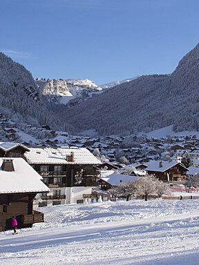
Conditions are looking great in Morzine
Another week of snow & sunshine in the Portes Du Soleil
The incredible start to 2019 continued this week with a mixture of snow and sun. After a slight lack of snow at the start of the winter, things improved a lot during the first few days of the new year.
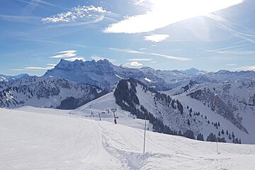
The snow kept coming with a heavy dump last weekend that continued into Monday. Tuesday and Wednesday brought beautiful sunshine and perfect snow. Mt Chery and Nyon had ideal conditions.

Before the snowfall last weekend, conditions were good everywhere due to the snowfall over the past couple of weeks. The heavy snowfall at the weekend just made things even better. As if that wasn’t enough, on Thursday the clouds came in and snow began falling once again. There was rain in Morzine itself to begin with, but the freezing level was only just above town. Over in Les Gets, snow was falling. By the afternoon the freezing level had dropped sufficiently for snow to begin falling in Morzine as well.
Whilst there wasn’t a huge amount of snowfall on Thursday it was enough to top up the existing base, which was already very good. Some of the best snow at the moment is to be found on Mt Chery on the Les Gets side. Elsewhere in the Portes Du Soleil the coverage is good over towards Linga and, heading even further from Morzine, Torgon and Les Crosets over in Switzerland. There really isn’t any one area where there is bad snow cover at the moment, and with the links open between all the resorts in the Portes Du Soleil it’s a perfect time to get out and explore the entire ski area.

Strong winds can often leave some higher, more exposed slopes very hard and even icy, but there is such good snow cover at the moment that the intermittent high winds during the week have not had too much of an adverse effect on the snow on the pistes. However, the high winds have meant that the off piste is not completely stable on the higher areas of the resort at the moment.
Around Fornet the wind has led to some large looking cornices forming, so be aware of the risks before thinking of going off piste. More snow is currently forecast for Sunday, although the amount expected has dropped in the past couple of days and it now looks like just a light dusting is on the way, but more is expected on Wednesday. This is also not expected to be a heavy snowfall, but will provide a nice top up across the resort.
As well as the expected snow, the weather next week is forecast to be very cold at around -10C, but dropping at times to -20C. This is great news for keeping the snow in place, but does mean that it is very important to wrap up warm. The weather is expected to be a mixture of cloud and sun throughout the week, as well as the snow that’s expected on Wednesday.
Almost all the lifts and pistes are open at the moment. To compare this winter to last year, we had much better conditions in December, but January brought high winds and rain. January this year is considerably better. The snow has built up steadily over a number of good snowfalls providing a more stable snowpack. The cold temperatures mean that the chances of rain at the moment are incredibly low, and hopefully the snow will continue to fall.