


Morzine Snow Report: 28th January 2013
After another bout of sunshine, snow is on the forecast once again!
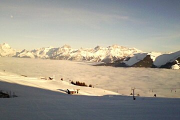
Thursday dawned sunny and bright, the on piste conditions were fabulous, and if you could be bothered to walk for it, the off piste was pretty ace too.
Friday saw similar conditions up high but unfortunately, cloud cover was rolling up from the bottom of the valleys. By lunch-time, only the top of the ski area was in the sunshine and you only had to drop about a hundred meters to be engulfed in the cloud. The skiing was still good but visibility was pretty poor low down.
Saturday dawned a bright start to the weekend. The sun was shining and it was fairly warm too. The pistes were still in great condition, and the powder hunters were heading slightly further afield to quench their thirst. Places like Mont Chery and Chapelle d’Abondance still have some good lines to be found. I enjoyed a little freestyle snowboarding in the Nike Chatel Snow-Park. This is really well built and has a great beginners line, as well as some huge kickers and rails. Unlike the Stash in Avoriaz, everything here is your standard metal and plastic park set up so it’s more like what you’d find at home in a Snowdome, or in most other resorts.
Sunday started bright again but as the day drew on, the light became flatter and flatter. By the afternoon, unless you had really good flat light lenses, you were unable to make neither head nor tail of the bumps or lumps on the piste. The weather front moving in is due to bring some fresh snow, hopefully up to twenty centimeters of the white stuff!
The weather forecast is predicting snow Sunday night, and into Monday morning. There is sunshine forecast for Monday afternoon before it's set to cloud up over night. Monday is going to be around minus seven temperature wise, including wind chill, at mid level. It’s set to warm up again on Tuesday with some light rain forecast at lower levels in the afternoon, and the milder temperatures are set to stay through Wednesday, with more rain that night. Thursday is set to be windy and with light rain again. The temperature should drop over night on Thursday and we might see a little snow. Friday should see snow and cloud, and Friday night should be snowy again!
With the fresh snow, do watch out for the avalanche risk, and take care on any steeper slopes. There is a lot of surface hoar about on lower slopes - this is that really pretty glittery looking snow that makes the town sparkle! That said, higher up there is less of this about, and most of the easily accessible snow here is well compressed from frequent use. Whilst this should make it more stable underneath, if it ices over before the new snow it could be dangerous so do take care! There is also a massive change in temperature around which will make it dangerous out there so do take care!
With fresh snow due for the start of the week, most people will be out powder hunting but the pistes will be great too. Watch out towards the end of the day though, as soft snow can make for some very moguly slopes come the end of the day. The morning skiing should be fantastic though, and if you follow the run round as you ski, you should always find some nice, slightly softened slopes to ski on. The slopes in the shade longest are usually icy in the morning.
It’s a fairly quiet week here in Les Portes du Soleil, so make the most of it. As soon as February hits it’s going to start to get busy again and the French holidays start mid Feb. The lift queues will get longer ad the slopes will get busier, enjoy the tranquility this week, and brace your self for February half term holidays, because they’re not far off now.
Make the most of the snow, it’s going to be good!
Bon ski!
Stats
-
Alt. Resort: 1800m
-
Alt. Summit: 2466m
-
High Temp.: Sud-Ouest
-
Alt. High Temp.: 1800m