© Giles Towler

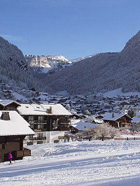
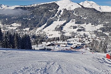
Fresh snow replaces icy pistes in Morzine
Perfect conditions throughout the Portes Du Soleil
What a difference a week makes. Following a sunny but somewhat icy new year’s week the clouds began closing in at the start of this week, and the snow started falling on Tuesday.
To begin with the snowfall was somewhat sporadic, but the freezing level stayed low and there was snow falling all the way down to Geneva.

By Wednesday the snow began to really fall heavily. Even in the morning there were patches of snow off the sides of the pistes that were almost knee deep, although the wind meant that conditions were quite variable. The snow really intensified in the afternoon and the whole of Morzine village was getting blanketed in snow. The snow continued into the evening, and there was cloud forecast for Thursday.

However, Thursday dawned with blue skies and plenty of fresh snow. The official estimates claim that there has been up to 40cm of fresh snow, but in some sheltered areas it felt like considerably more, with over knee-deep powder in some places. The temperatures were cold, around -9C, and this was exacerbated by very high winds. Higher areas, such as Arare and Fornet, took the brunt of the wind, and the Super Morzine lift was closed briefly as a result. This meant that some of the higher slopes were slightly wind blasted, but as soon as skiers drop down from the very highest pistes, conditions improved massively. The absolute worst conditions during the day were hard packed snow, with the best on piste conditions being packed powder. Off piste conditions are good at the moment, although the wind has made some faces more dangerous and there is still the chance of hitting some rocks, so caution is advised.

Even the lower slopes now have good snow cover and the continued cold temperatures should keep that snow. This time last year rainfall had affected the incredible early season snow. This year there might not have been as much snow at the start of the season (last year was exceptional in that regard) but things have really picked up now. The great news is that there is even more snow forecast for the weekend, so whilst things are good at the moment, by next week they could be even better. It might cause some delays for people coming to resort, but it will be well worth it with heavy snowfall forecast till Tuesday, which is expected to be sunny. It looks likely that the freezing level will not be quite as low as it was earlier this week, however, so hopefully people won’t encounter difficulties coming and going from resort.

Currently, the majority of lifts and the links between resorts are open. The conditions look set to improve even further and, with the current low temperatures, the snow cannons have been running on the lower pistes to ensure that everywhere has the best possible snow cover. Overall, whilst it might have seemed like a slightly slow start to the season, it has been better than in some previous years and things now are improving rapidly. Following the busy New Year week the pistes have got a lot less busy and with the improved snow offering even more choice of places to go it’s easy to find quiet, secluded skiing. The back of Mt Chery, for example, is almost completely deserted and the snow cover is excellent almost all the way to the bottom, with just a few slightly icy areas at the very lowest parts of the slopes.