© Giles Towler

© Giles Towler

© Giles Towler


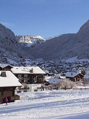
Midweek top-up of snow for Morzine
With epic snowfall on the forecast for the Portes du Soleil
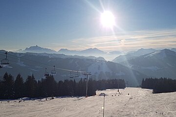
It’s been another good week in Morzine with good conditions at the start of the week and more snow in the middle of the week.
The week started cold and has remained that way so far. Some forecasts had suggested that the temperature could drop as low as -20C, but in reality -10C was about as cold as it got. This meant that the snow stayed excellent right up to Wednesday, when it snowed approximately 5cm to 10cm. This wasn’t enough to make a huge difference, but the top up did keep the pistes well covered.

The best snow is on the higher pistes at the moment. Heading over to Avoriaz, the snow on Fornet is some of the best, as well as the top of Mossettes heading over to Switzerland. In Morzine and Les Gets some of the best snow is up on Nyon and the pistes on Super Morzine. Before Wedneday there were some slightly icy patches on the lower slopes such as the very bottom of the Pleney, the bottom of the Chavannes and the bottom of Ardent. However, the extra snow that fell should have made enough of a difference to improve conditions. The pistes are mostly quiet with a couple of weeks to go before the busy holiday weeks of February.
Some of the less skied areas such as Mt Chery can be almost deserted during the day. By the end of the day, around 16:00, most of the mountain is almost empty as people have probably had enough of the cold by then. There are a few clouds around at the moment, but still enough sunshine to provide good visibility. The clouds at the moment are just a taste of what is to come, as a huge storm looks set to hit Morzine and Les Gets in the next couple of days.

At the moment the forecast is predicting heavy snowfall starting late on Saturday and carrying on all day Sunday and Monday. Holidaymakers arriving this Saturday will probably have an easier time getting to resort than those arriving on Sunday, and anyone driving to resort should ensure they have snow chains and know how to fit them, as it’s no fun trying to work out how to do so for the first time at the side of the road in Les Gets in a blizzard. It looks as though Morzine and Les Gets should see at least a metre of snow over the weekend. Sunshine is expected on Tuesday, so if the current forecasts are accurate (fingers crossed) Tuesday could be one of the best days of the season. Anyone heading out looking for powder needs to take proper precautions though. After so much snow in such a short time, it’s likely that the snow pack will need a bit of time to become stable.

The forecast is also predicting more snow throughout the week, with a larger dump at the weekend, although obviously the further ahead a forecast is the less accurate. Whatever happens though it’s a reasonably safe bet now that this weekend will see a huge snowfall. Currently there is over a metre of snow on the pistes at 1800m and 185cm on the highest slopes of Avoriaz. Anyone skiing this weekend should stay in the trees to get the best visibility, and wait for some sun (hopefully) on Tuesday before heading up high.